The Overland Track (2019)
Wed 30 December 2020
Update 2021-01-01: added some consideration on calorie intake vs. expenditure.
At the beginning of 2019, I spent two months road-tripping and camping in Victoria and Tasmania. In February I had the chance to walk the Overland Track, one of Tasmania's most iconic multi-day hikes.
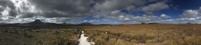
The 70 something Km trail stretches from Cradle Mountain to Lake St. Clair, and in the summertime is usually walked southbound. Although very well kept, and supported by a network of huts, the trail crosses relatively remote areas of the country. It's a rather popular track and many resources are available online. Trip reports vary from guided expeditions to hardcore solo winter bushwalks. Ultimately though, most of them are written from the perspective of hikers based in Australia and know the local wilderness. This article is written from the point of view of someone planning from outside Tasmania.
Walking pass
In the busy summer months, there are limited spots available on the trail. A pass must be booked well in advance at https://bookings.overlandtrack.com.au/. The pass will indicate a departure date, but other than that there are no time constraints to complete the trail. It's good to be flexible, and adjust based on fitness level and weather conditions. I originally planned to walk the OT in 7 days, but I was forced to wrap it in 5 (more on this later). The huts along the way are well spread out allow for flexibility, and it's easy to pull a long day and skip one, or camp out and wait for the weather to clear.
Resources
There's plenty of material available online, but all in all the most valuable resources have been the following books:
- John Chapman, Overland Track.
- The Overland Track - One Walk Many Journeys that comes with the walking pass.
Both are great references. If you plan on doing side trips, I can highly recommend Chapman's for its very good topography and route descriptions (e.g. to summit Ossa). I spent quite some time doing fine-tuning for equipment and hiking hacks. I terrific source of information was the Bushwalk.com forum.I recommend keeping an eye on the forum to be up to date with regards to the state of the trail. There is one caveat: many trip reports seem skewed towards expedition-style gear (big packs, heavy-duty boots, lots of food, cooking equipment). While this sounds great for a family trip, I opted to trade comfort for a more lightweight 50L pack (more on this below).
PLB: yes or no?
tl:dr: yes
I never even got close to needing it, but having a PLB with me gave me a lof piece of mind. Equally important, it gave peace of mind to the family waiting for me at the other end of the trail.
I rented mine from Service Tasmania, and had to return it to the same location where I picked it up (Hobart). Some companies offer more flexibility (e.g. receive it and return it by mail), but since I was I did not have a fixed address on the island that was not an option.
Departure
The OT starts at Cradle Mountain National Park. There's a free shuttle bus service that connects the Visitor Cente to the starting point of the trail. Fares start at 8 am. Before starting the walk you'll need to check-in at the park's Visitor Center and collect the OT pass; you'll have to keep this pass with you at all times while on the trail and be ready to show it to rangers upon requests. You'll be able to collect the pass and begin the walk only during the Visitor Center office hours.
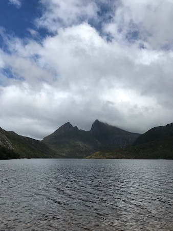
I arrived at Cradle Mountain National Park a couple of days ahead of departure. The area is beautiful. I enjoyed the Dove Lake Circuit walk and many other shorter walks in the park. In retrospect, it has been one of the highlights of the whole trip, and the only couple of days were I've got to see some sun.
Arrival
The canonical endpoint of the trail is close to the Visitor Center at Lake St. Clair. From Narcissus, the last but one of the OT huts, Lake St. Claire can be reached in two ways.
- By foot, along the last section of the OT. There's an additional shelter on this short trail, located at Echo Point hut.
- By ferry, from the Narcissus hut jetty. Boat fares are organized by an independent company (and will set you back ~40AUD). If you want to take this shortcut, the trip should be booked upfront. There's an RC station at the hut that lets you contact the ferry, and schedule a pick-up. Note that in case of bad weather, you might be refused a lift. https://www.lakestclairlodge.com.au/about-lake-st-clair/lake-st-clair-ferry/.
There are many options to arrange transportation from Lake St. Claire to Launceston and Hobart. I opted for taking the bus. Reservation can be made at https://www.tassielink.com.au/. One quirk (at the time) is that I was required to share my credit card details, in clear, over e-mail to confirm the booking. Mildly upsetting, if it wasn't that I carried a spare visa electron for this kind of occasion. To be fair, I think confirming over the phone would have worked too but I chose email to have a receipt of the payment. YMMV.
On the reservation, you'll have to indicate a departure date, service (e.g. Lake St. Clair to Hobart), and departure time. Be aware that the bus does not drive every day of the week to all destinations.
It might be tricky to leave Narcissus on time to catch the bus on the same day (if feasible at all). I arrived at the destination to days before the bus scheduled departure, and I opted to spend some time at St. Claire Lodge. The initial plan was to camp it out, but due to the weather, I upgraded to a bed in a Drumlin (that would be like a shared 3-4 people bedroom in a hostel).
Route
My original plan was to follow the canonical route described in Chapman's book. Weather conditions forced me to change the schedule a bit, and I ended up with the following splits (click on the link to access the GPS traces on Strava):
- Day 1. Ronny Creek to Windermere Hut (via Waterfall Valley). Part 1 and Part 2.
- Day 2. Windermere to Pelion. Route.
- Day 3. Pelion to Kia Ora. Part 1 Part 2 Part 3.
- Day 4. Kia or to Narcissus. Part 1 Part 2 Part 3 Part 4 Part 5.
- Day 5. Narcissus to Cynthia Bay (via Echo Point). Part 1 Part 2.
GPX files can be downloaded at https://github.com/gmodena/overland-track.
Weather, snakes, and pests
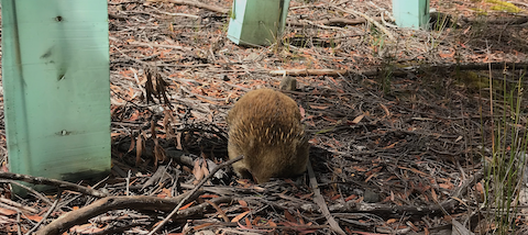
Weather, for the most part, sucked. It rained for the whole five days (even snowed a bit on the last one), with only a few hours of sun and visibility. This made some of the side trips impossible (I aborted the Mt. Ossa climb a couple of hundred meters shy of the summit), but made the rain forest walk - and waterfalls - gorgeous. I've learned two lessons: invest in good gaiters and Goretex pants that can be worn without removing your shoes. A side effect of all the rain, is that I did not see a single snake on the whole trip. I did encounter quite a few leeches though, especially around Kia Ora (the pond is infested) and on the way to Narcissus.
Shelter & Sleeping system
Some huts (Pelion, Narcissus) offer more boarding space than others (Windermere). Depending on the season they might get crowded. Regardless of the season, they will be noisy. . I planned to camp out as much as possible, and most of my gear budget when in the sleeping system. I wanted something as light as possible, yet still able to withstand bad weather. I settled for the ridiculously light (for my standards) Flycreek 2 persons, tent, and a Therma-Rest NeoAir XLite sleeping mat. The sleeping bag was a tried and trusted no-name bag, rated for 0C. The tent and mat were great, but sleeping felt cold-ish when sleeping on wooden platforms at around 5C, probably due to humidity. I missed a pair of good earplugs; it got noisy under heavy rain.
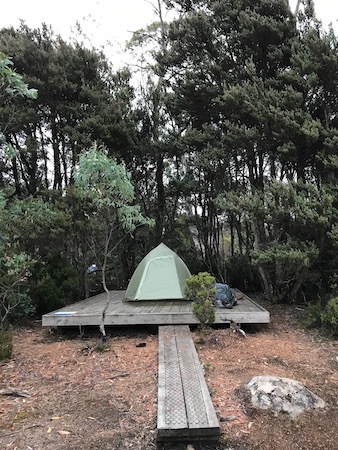
The tent platforms were many and generally available. It required some creativity to pitch the Flycreek on them, but having extra cords, of different lengths, helped.
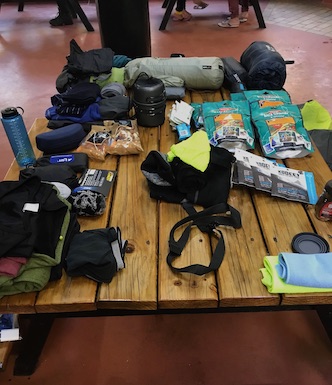
Pack
The Park Services hand out a gear list, that you are asked to review and acknowledge. This what I carried with me in a 50L Osprey Atmos pack. I used waterproof dry sacks to keep things organized and wrapped food, electronics, and maps in zip lock bags.
- Tent
- Sleeping bag + liner
- Sleeping mat
- 2x base layer (walking/sleeping)
- 1x walking clothes
- 1x walking clothes as a backup (which I did not use)
- 1x camp clothes
- Too many socks
- Rain gear (over pants and hard sell)
- Microfiber towels
- Toiletterie (biodegradable soap and hand sanitizer)
- Stove, pan, and isobutane canister
- Foldable cup & a spork
- Food
- Water
- PLB
- Maps
- Electronics (phone, e-book reader)
- Sunglasses
- Trash bag
Food & water
Food was the larger bit, in terms of weight and volume, of the pack. I set a caloric intake goal of 1600-1800 kcal per day. This is slightly below the expected consumption at 70Kg body weight but was plenty to make me feel energized while keeping pack weight in check. YMMV. My (estimated) BMR is around 1300 kcal/day, and according to the smart watch recording I burned approx 2500 active kcal a day on average. This intake vs. expenditure ratio was manageable for 5 days of walking, but would not be safe for longer trips. I used to consume one big 800-1000 kcal meal at camp in the evening and snacked on nuts/beef jerky/dried fruit throughout the day. I took a 1.5L water bottle, which I refilled and purified at the huts with chlorine dioxide tablets. It's easy to forget to drink and eat during the day; the risk of dehydration is real. I did not pay attention to it during my second day and finished the hike much more tired than I should have. The groceries list for 8 days (I budged extra to have a backup) is shown in the table below.
| Item | Quantity | KCal/quantity |
|---|---|---|
| Backountry Cousine (2 servings) | 4x | 800 / package |
| Backountry Cousine (1 servings) | 2x | 400 / package |
| Nuts | 500g | ~630 / 100g |
| Dried apricots | 200g | 300 / 100g |
| Beef jerky (~30g serving) | 5x | 120 / serving |
| Peanut Butter (jar) | 1x | 100 / spoon |
Table: Groceries list
500g of nuts were too much, I ate roughly 3/4 of the trail mix. The apricots were a nice addition but probably added too much sweetness to the trail mix. Snacking turned out to be a good strategy: I did not have much time to stop and take long breaks, and weather conditions were often too inclement to cook a meal. As much as I like peanut butter, it turned out to be a bit boring (and chewie); something oatmeal-based might be a good replacement/supplement.
Conclusion
All in all, I had a great experience. The preparation was a lot of fun, and walking the whole thing was both a test and a learning experience (e.g. learning to pitch a tent under the rain). The communal areas at the huts offered plenty of socializing opportunities, and a way to share tips and stories. Although the walk is in a relatively remote part of Tasmania, I met interesting characters along the way and never really felt alone. All in all the horrible weather conditions provided a great source of Type 2 fun, though it made some side trips pretty dangerous. I had the bad idea to attempt a summit of Ossa in sub-par cloudy/misty conditions, and the good foresight to turn around before the weather got really bad. I hope to be back and get to the top one day.